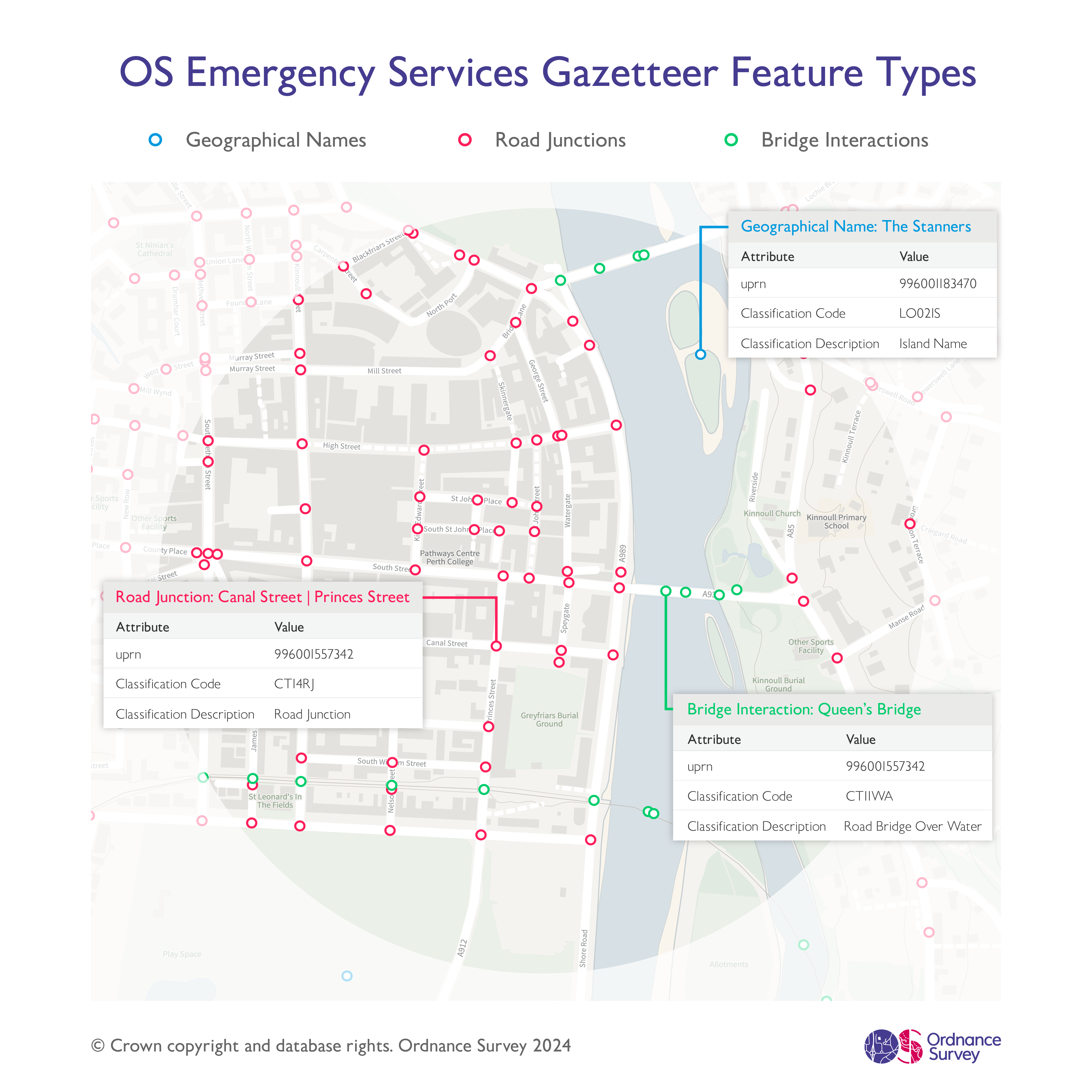
Image showing examples of the three types of features available in the OS Emergency Services Gazetteer – geographical names, road junctions, and bridge interactions. A background map has been included to provide context.
Image showing examples of the three types of features available in the OS Emergency Services Gazetteer – geographical names, road junctions, and bridge interactions. A background map has been included to provide context.
Example image showing OS ESG slipways, with attribution pulled out for one slipway. A background map has been included to provide context.
Example image showing OS ESG weirs, with attribution pulled out for one weir. A background map has been included to provide context.
| Dataset Name | Dataset Description |
|---|---|
| Name and Location of Road Junctions | Road Junction features will be provided for junctions where two or more named or numbered roads intersect. For junctions which have an official name or number, the official names will be provided where identified. |
| Geographical Names | A subset of Geographical Names features, such as named water and named geographic features, will be provided in the OS ESG. Extensive features greater than 20km² will not be provided. |
| 🔃 Bridge Interactions | Additional attribution for Bridge features which identifies interactions between any networks passing over and / or under a bridge. 🆕 Names and / or numbers for some of the bridge features supplied via third parties are provided in the OS ESG as alternative ways to identify bridge features. |
| Tunnels | OS ESG Tunnel centroid point features are provided for all tunnel features in OS NGD Compound Structures. OS ESG Tunnel portal centroid point features are provided for a subset of tunnel features in OS NGD Compound Structures. Tunnel features of classification Subway or Pedestrian Tunnel portal will not be provided where the tunnel feature is less than 75m in length (where length is defined as the longest straight line distance between any possible portal points). |
| 🆕 Slipways | Slipways features represent large platforms or made areas that slope down into the water from which boats can be launched. Please note that to avoid duplication, slipways with a UPRN in the NAG won't appear in OS ESG data; however, they will still be shown in OS Addressing products. |
| 🆕 Weirs | Weirs features represent low dams built across a river or stream that either control the flow of water or change its direction. Please note that to avoid duplication, weirs with a UPRN in the NAG won't appear in OS ESG data; however, they will still be shown in OS Addressing products. |
Map image showing the third-party organisations that contributed to the Third-Party Bridge Information data found within the Bridge Interactions dataset of the OS ESG.