> For the complete documentation index, see [llms.txt](https://docs.os.uk/os-downloads/llms.txt). Markdown versions of documentation pages are available by appending `.md` to page URLs; this page is available as [Markdown](https://docs.os.uk/os-downloads/products/areas-and-zones-portfolio/code-point-with-polygons/code-point-with-polygons-getting-started-guide.md).
# Code-Point with Polygons Getting Started Guide
This getting started guide provides instructions for using Code-Point with Polygons in different software applications. Users with limited technical knowledge will be able to follow this guide.
Code-Point with Polygons is a dataset that contains the notional area of postcode units, allowing customers to display and analyse any data collected at the postcode level.
The polygons within the product are derived from georeferenced Royal Mail Postal Address File (PAF) delivery addresses. A process is undertaken to create a set of polygons around individual address records within a postcode. This is called a Thiessen process and the polygons are the result of a mathematical computation that creates polygons from point data. In this way, mathematically consistent boundaries are created between distinct postcode groups, creating this notional boundary set.
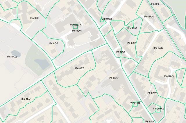
Polygons containing postcodes as supplied in the Code-Point with Polygons product
Postcode unit boundaries are, by definition, only the delivery point or collection of delivery points that constitutes the postcode units. The boundary is therefore a notional one, the position of which is arbitrary. What has been created, however, is a set of boundaries that follows a consistent logic and portrays the notional footprint of each postcode unit. The boundary encloses every delivery address for which positional data of sufficient quality is available, and which follows major physical features that could reasonably be regarded as part of the postcode boundary.
This getting started guide focusses on using the product in shapefile, MapInfo TAB file and MapInfo MID / MIF formats. For guidance on using the product in vector tiles or GeoPackage formats please see the following getting started guides:
* [Getting Started with Vector Tiles](/os-downloads/resources/product-resources/getting-started-with-geopackage-and-vector-tiles-guides/getting-started-with-vector-tiles.md)
* [Getting Started with GeoPackage](/os-downloads/resources/product-resources/getting-started-with-geopackage-and-vector-tiles-guides/getting-started-with-geopackage.md)
## Index
This getting started guide includes the following sections:
* [Using the vertical street lookup](/os-downloads/products/areas-and-zones-portfolio/code-point-with-polygons/code-point-with-polygons-getting-started-guide/using-the-vertical-street-lookup.md)
* [Creating single-space postcode](https://docs.os.uk/os-downloads/products/areas-and-zones-portfolio/code-point-with-polygons/pages/7mzSHdZoMyI8SDv6qAQR#id-3.1-centroids-and-polygons)
* [Data measures](/os-downloads/products/areas-and-zones-portfolio/code-point-with-polygons/code-point-with-polygons-getting-started-guide/data-measures.md)
---
# Agent Instructions
This documentation is published with GitBook. GitBook is the documentation platform designed so that both humans and AI agents can read, navigate, and reason over technical content effectively. Learn more at gitbook.com.
## Querying This Documentation
If you need additional information that is not directly available in this page, you can query the documentation by asking a question.
Perform an HTTP GET request on the following URL with the `ask` and `goal` query parameters:
```
GET https://docs.os.uk/os-downloads/products/areas-and-zones-portfolio/code-point-with-polygons/code-point-with-polygons-getting-started-guide.md?ask=&goal=
```
`ask` is the immediate question: it should be specific, self-contained, and written in natural language.
`goal` is what the user is ultimately trying to achieve, the reason they need the answer. Sharing it helps GitBook give you a better, more relevant answer. A goal is most helpful when it describes the outcome the user wants rather than restating the question. For example, with `ask=how do I create an API token`, a goal like `automate deployments from our CI pipeline` lets GitBook tailor the answer to that use case.
The response will contain a direct answer to the question and relevant excerpts and sources from the documentation.
Use this mechanism when the answer is not explicitly present in the current page, you need clarification or additional context, or you want to retrieve related documentation sections.