# Product structure

OS MasterMap Topography Layer – Building Height Attribute consists of three absolute height values and two relative height values for each building polygon. The included structures – tanks, chimneys (industrial) and glasshouses – are not distinguished from the buildings in this dataset. As such, they are subject to the same attribution and parameters. The unit of measurement used for absolute and relative building heights is metres.

## Absolute heights <a href="#bookmark5" id="bookmark5"></a>

The absolute building heights describe the height of the buildings and selected structures at three distinct points. They are measured against Ordnance Datum Newlyn (ODN) and require the use of other height products (for example, [OS Terrain 5](/os-downloads/products/land-and-terrain-portfolio/os-terrain-5.md)) to give meaningful heights to the building features. If we have been unable to calculate a valid value or have insufficient confidence in a value for any of these attributes, the fields will be populated as NULL.

## Relative heights <a href="#bookmark6" id="bookmark6"></a>

Relative building heights have been generated from the absolute height values. These provide height values that can be utilised without the use of other height products. If we have been unable to calculate a valid value or have insufficient confidence in a value for any of these attributes, the field will be populated as NULL.

## Model overview for CSV <a href="#bookmark7" id="bookmark7"></a>

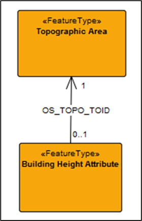
<figure><img src="/files/NOVHhT6mD7mxbEKq2MKo" alt="h-level overview data model showing the relationship between the Topographic Area feature type in OS MasterMap Topography Layer and the Building Height Attribute feature type."><figcaption><p><em>High-level overview data model showing the relationship between the Topographic Area feature type in OS MasterMap Topography Layer and the Building Height Attribute feature type.</em></p></figcaption></figure>

## UML model of Building Height Attribute data in CSV format <a href="#bookmark8" id="bookmark8"></a>

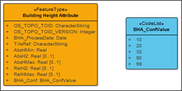
The Unified Modeling Language (UML) model of OS MasterMap Topography Layer – Building Height Attribute in CSV format can be seen in the figure below:

<figure><img src="/files/6k5JwCuM5nEhUu9pyblp" alt="UML model showing the OS MasterMap Topography Layer – Building Height Attribute feature type and code list for the CSV supply. The single feature type of Building Height Attribute is shown in an orange box with its 10 attributes, all of which are listed and described in detail in the second table in Section 2.5. The single code list of BHA_ConfValue is shown in an blue box with the list of values (10, 20, 30, 90 and 99)."><figcaption><p><em>UML model showing the OS MasterMap Topography Layer – Building Height Attribute feature type and code list for the CSV supply.</em></p></figcaption></figure>


---

# Agent Instructions: Querying This Documentation

If you need additional information that is not directly available in this page, you can query the documentation dynamically by asking a question.

Perform an HTTP GET request on the current page URL with the `ask` query parameter:

```
GET https://docs.os.uk/os-downloads/products/buildings-and-infrastructure-portfolio/os-mastermap-topography-layer-building-height-attribute/os-mastermap-topography-layer-building-height-attribute-technical-specification/product-structure.md?ask=<question>
```

The question should be specific, self-contained, and written in natural language.
The response will contain a direct answer to the question and relevant excerpts and sources from the documentation.

Use this mechanism when the answer is not explicitly present in the current page, you need clarification or additional context, or you want to retrieve related documentation sections.