> For the complete documentation index, see [llms.txt](https://docs.os.uk/os-downloads/llms.txt). Markdown versions of documentation pages are available by appending `.md` to page URLs; this page is available as [Markdown](https://docs.os.uk/os-downloads/products/land-and-terrain-portfolio/os-mastermap-sites-layer/os-mastermap-sites-layer-technical-specification/data-specification-overview.md).
# Data specification overview
## Structure
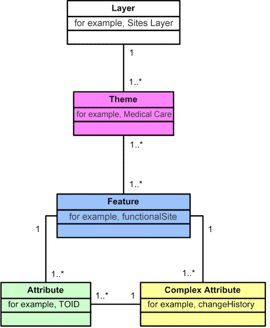
This data specification works within the existing structure of OS MasterMap as represented in the Unified Modelling Language (UML) class diagram below:
UML class diagram representation of OS MasterMap layer
## Layers
A layer is a set of related geospatial data which is then divided into one or more themes (much like OS MasterMap Topography Layer). These themes can be used together to form an end-user application.
## Themes
Within the Sites Layer, features belong to only one theme. A theme is a logical collection of features that have been grouped according to their classification or relationships. The primary purpose of themes is to enable easier selection and interrogation of features by the user. Themes do not form part of the classification of a feature and do not affect the feature life cycle rules. The Sites Layer is currently composed of seven themes which are defined fully on the [Theme definitions](/os-downloads/products/land-and-terrain-portfolio/os-mastermap-sites-layer/os-mastermap-sites-layer-technical-specification/theme-definitions.md) pages.
## Features
Features are digital representations of real-world concepts such as a building, road or barrier. The life cycle of a feature, its creation, modification and deletion are managed to most appropriately reflect the life cycle of the abstracted real-world concept that they depict.
## Attributes
An attribute is any item of information contained within an OS MasterMap feature. The TOID and the geometry of the feature are both attributes.
---
# Agent Instructions
This documentation is published with GitBook. GitBook is the documentation platform designed so that both humans and AI agents can read, navigate, and reason over technical content effectively. Learn more at gitbook.com.
## Querying This Documentation
If you need additional information that is not directly available in this page, you can query the documentation by asking a question.
Perform an HTTP GET request on the following URL with the `ask` and `goal` query parameters:
```
GET https://docs.os.uk/os-downloads/products/land-and-terrain-portfolio/os-mastermap-sites-layer/os-mastermap-sites-layer-technical-specification/data-specification-overview.md?ask=&goal=
```
`ask` is the immediate question: it should be specific, self-contained, and written in natural language.
`goal` is what the user is ultimately trying to achieve, the reason they need the answer. Sharing it helps GitBook give you a better, more relevant answer. A goal is most helpful when it describes the outcome the user wants rather than restating the question. For example, with `ask=how do I create an API token`, a goal like `automate deployments from our CI pipeline` lets GitBook tailor the answer to that use case.
The response will contain a direct answer to the question and relevant excerpts and sources from the documentation.
Use this mechanism when the answer is not explicitly present in the current page, you need clarification or additional context, or you want to retrieve related documentation sections.