> For the complete documentation index, see [llms.txt](https://docs.os.uk/os-downloads/llms.txt). Markdown versions of documentation pages are available by appending `.md` to page URLs; this page is available as [Markdown](https://docs.os.uk/os-downloads/products/land-and-terrain-portfolio/os-mastermap-sites-layer/os-mastermap-sites-layer-technical-specification/geometry.md).
# Geometry
This section defines the geometric data types used by features of the OS MasterMap Sites Layer. A UML diagram is used to support the data type descriptions.
## Features and spatial data types
The following table details the data type of the geometric attributes of OS MasterMap Site Layer features. Each feature type has a spatial attribute called ‘geometry’. The data type of this attribute is given in the third column of the table.
| Feature type | Spatial attribute | Data type of geometry attribute | For details, see: |
| -------------- | ----------------- | ------------------------------- | ------------------------------------------------------------------------------------------------------------------------------------------------------------------------------------------------- |
| functionalSite | geometry | Polygon | [Functional site extent overview](/os-downloads/products/land-and-terrain-portfolio/os-mastermap-sites-layer/os-mastermap-sites-layer-technical-specification/functional-site-extent-overview.md) |
| accessPoint | geometry | Point | [access point overview](https://docs.os.uk/os-apis/) |
| routingPoint | geometry | Point | R[outing point overview](/os-downloads/products/land-and-terrain-portfolio/os-mastermap-sites-layer/os-mastermap-sites-layer-technical-specification/routing-point-overview.md) |
## Geometric data types
### Point
A point is used to specify a single horizontal location by a coordinate pair in a given spatial reference system.
**Example**
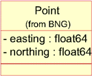
A point defined in the BNG reference system has easting and northing coordinates in units of metres, where the easting is in the range 0 to 700000 and the northing is in the range 0 to 1300000.
Point defined in the BNG reference system
Example class model for point (from BNG).
**Example class model**
### Polygon
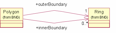
A polygon is a single closed region on the spatial reference system projection plane, defined by a set of geometric rings that represent the boundaries. A polygon has one outer boundary and zero or more inner boundaries (holes in the polygon). The inner boundaries must not cross each other or contain other inner boundaries. Coordinates in outer boundaries are oriented in an anticlockwise direction; coordinates in inner boundaries are oriented in a clockwise direction. In the Geography Markup Language (GML) data, these are implemented as a Surface containing a single Polygon Patch, with the exterior and any interior boundaries represented as a LinearRing.
**Example**
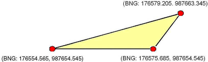
Polygon defined in the BNG reference system.
**Example class model**
Example class model for polygon in BNG.
### Multi-polygon
A multi-polygon is used where a single functional site consists of separate areas, such as a school on both sides of a road. Each polygon is as described above. In GML, this is represented with a gml:MultiSurface having a number of ‘surface members’ each of which is a single gml:Surface.
---
# Agent Instructions
This documentation is published with GitBook. GitBook is the documentation platform designed so that both humans and AI agents can read, navigate, and reason over technical content effectively. Learn more at gitbook.com.
## Querying This Documentation
If you need additional information that is not directly available in this page, you can query the documentation dynamically by asking a question.
Perform an HTTP GET request on the current page URL with the `ask` query parameter, and the optional `goal` query parameter:
```
GET https://docs.os.uk/os-downloads/products/land-and-terrain-portfolio/os-mastermap-sites-layer/os-mastermap-sites-layer-technical-specification/geometry.md?ask=&goal=
```
`ask` is the immediate question: it should be specific, self-contained, and written in natural language.
`goal` is optional and describes the broader end goal you are ultimately trying to accomplish on behalf of the user. GitBook uses it to tailor the answer towards what is most useful for that goal.
The response will contain a direct answer to the question and relevant excerpts and sources from the documentation.
Use this mechanism when the answer is not explicitly present in the current page, you need clarification or additional context, or you want to retrieve related documentation sections.