# ArcMap

These instructions are based on ArcMap version 10.8.1. and assume you have set the default coordinate reference system to British National Grid (EPSG 27700).

{% hint style="info" %}
*if your ArcMap is older than version 10.0, or if you do not have access to the Quick Import (Data Interoperability) extension, use the translation tools available in FME and QGIS to convert the GML data to shapefiles.*
{% endhint %}

{% hint style="info" %}
Certain versions of ArcMap (for example, version 10.8.1) require GeoPackages to have a spatial index added before the data can be viewed on the map. This can be done in the Catalog by opening the Feature Class Properties window within the 'Indexes' page.

![](/files/6ka5yPiHIkmXfphC1ouy)
{% endhint %}

## Loading and displaying the GML supply using the Quick Import tool <a href="#id-4.1-loading-and-displaying-the-gml-suppl" id="id-4.1-loading-and-displaying-the-gml-suppl"></a>

You can import GML data into ArcMap using the Quick Import tool that converts the GML into file geodatabase (.gdb).

{% hint style="info" %}
*Due to the large file size, some 5km tiles (especially within larger cities) may take time to process.*
{% endhint %}

### To load GML data into ArcMap:

1. Open ArcCatalog and click and  (ArcToolbox icon) in top toolbar to open the ArcToolbox.

<figure><img src="/files/sFkDRToWU1EQN8Pv0Qpp" alt="ArcMap ArcCatalog panel highlighting the ArcToolbox icon"><figcaption><p>ArcMap ArcCatalog panel highlighting the ArcToolbox icon</p></figcaption></figure>

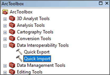
2. In ArcToolbox, expand *Data Interoperability Tools* and click *Quick Import*.

<figure><img src="/files/rXKdJqPr1wpCjE2uhTWr" alt="ArcMap’s ArcToolbox showing Data Interoperability Tools > Quick Import option" width="313"><figcaption><p>ArcMap’s ArcToolbox showing <em>Data Interoperability Tools > Quick Import</em> option</p></figcaption></figure>

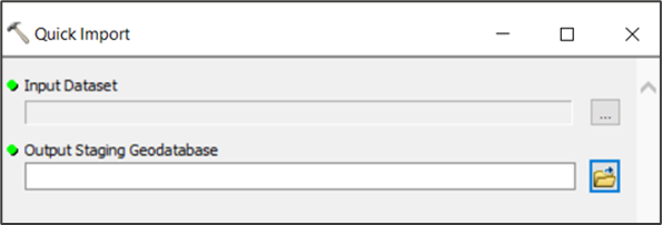
3. In the Quick Import dialog, click … (next to the Input Dataset field), and navigate to and select your OS MasterMap Topography GML data.

<figure><img src="/files/CpzW3VEo0AUmNnnAJJIl" alt="ArcMap Quick Import dialog" width="446"><figcaption><p>ArcMap Quick Import dialog</p></figcaption></figure>

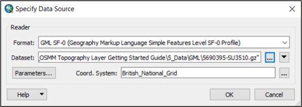
4. In the Specify Data Source dialog:
   * Format: *GML SF-0 (Geography Markup Language Simple Features Level SF-0 Profile)* will be detected automatically.
   * Coord. System: Enter *British\_National\_Grid* or click … and select it in the dialog.
   * Click *OK*.

<figure><img src="/files/XOiQiSzwZVYtHEiTklSB" alt="ArcMap Specify Data Source dialog" width="446"><figcaption><p>ArcMap Specify Data Source dialog</p></figcaption></figure>

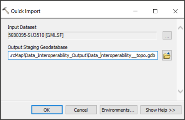
5. In the Quick Import dialog:
   * Output Staging Geodatabase field: Click  (file browser icon), navigate to and name the file geodatabase (.gdb) folder, and click *Save*.
   * Click *OK* to start the Quick Import.<br>

     <figure><img src="/files/yh9yzedsTEvByIwXVJTy" alt="ArcMap Quick Import dialog showing example information in the Input Dataset and Output Staging Geodatabase fields"><figcaption><p>ArcMap Quick Import dialog showing example input and output information</p></figcaption></figure>

When the import process is complete, a message will display in ArcCatalog. To display the GML data in ArcMap:

1. Open an existing project or create a new one.
2. In the top toolbar, click ![ArcMap Add Data icon](/files/XThim4wGSKfBLLo0yljf) (Add Data icon).

<figure><img src="/files/Vvdtlxld7lzugeOPGyb0" alt="ArcMap UI showing Add Data action" width="446"><figcaption><p>ArcMap UI showing Add Data action</p></figcaption></figure>

3. In the Add Data dialog:
   * Navigate to the file geodatabase created in the previous procedure. *If the relevant folder does not display, click* ![ArcMap Connect to Folder icon](/files/r8csOp4S5dlov9DtpggW) *(Connect to Folder icon) and navigate to the file geodatabase folder from there.*
   * Select the layers you want to load. *You can select multiple layers at the same time to save repeating these steps for each layer in the file geodatabase.*&#x20;
   * Click *Add*.

<figure><img src="/files/ewszyZGEBJ3IAejwYUyf" alt="ArcMap Add Data dialog showing selected OSMM Topography Layer file geodatabase layers" width="446"><figcaption><p>ArcMap Add Data dialog showing selected OSMM Topography Layer file geodatabase layers</p></figcaption></figure>

Your geodatabase layers will now display in both the Table of Contents panel and the map area.

### Loading and displaying shapefiles <a href="#id-4.2-loading-and-displaying-shapefiles" id="id-4.2-loading-and-displaying-shapefiles"></a>

As an alternative to using ArcMap’s Quick Import tool (previous section), you can convert your GML data to shapefile using FME and QGIS, and then add the shapefiles directly to ArcMap.

To load shapefiles into ArcMap

1. Open an existing project or create a new one.
2. In the top toolbar, click ![ArcMap Add Data icon](/files/rLovV54Htek5rRZMqej1) (Add Data icon).

<figure><img src="/files/SLP3GXn9bj5KUrMyeN1w" alt="ArcMap UI showing Add Data action"><figcaption><p>ArcMap UI showing Add Data action</p></figcaption></figure>

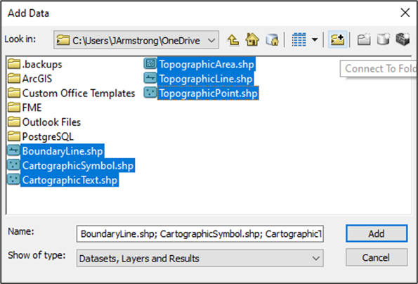
3. In the Add Data dialog:
   * Navigate to the shapefiles you want to load. *If the relevant folder does not display, click* *(Connect to Folder icon) and navigate to the file geodatabase folder from there.*
   * Select the shapefiles that you want to load. *You can select multiple layers at the same time to save repeating these steps for each shapefile.*
   * Click *Add*.<br>

     <figure><img src="/files/AOyibrUTvxeo3j0MYZNM" alt="ArcMap Add Data dialog showing selected OSMM Topography Layer shapefile layers" width="446"><figcaption><p>ArcMap Add Data dialog showing selected OSMM Topography Layer shapefile layers</p></figcaption></figure>

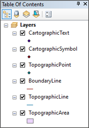
Your shapefiles will now appear in both the Table of Contents panel and the map area.

You may need to reorder the layers to see the data correctly. You can reorder layers using drag and drop. We recommend the following layer order: *CartographicText*, *CartographicSymbol*, *TopographicPoint*, *BoundaryLine*, *TopographicLine* and *TopographicArea*.<br>

<figure><img src="/files/2XT8KPKDpZoN8xUVmDcZ" alt="ArcMap Table Of Contents showing OSMM Topography Layer layers" width="224"><figcaption><p>ArcMap Table Of Contents showing OSMM Topography Layer layers</p></figcaption></figure>


---

# Agent Instructions: Querying This Documentation

If you need additional information that is not directly available in this page, you can query the documentation dynamically by asking a question.

Perform an HTTP GET request on the current page URL with the `ask` query parameter:

```
GET https://docs.os.uk/os-downloads/products/maps-and-imagery-portfolio/os-mastermap-topography-layer/os-mastermap-topography-layer-getting-started-guide/arcmap.md?ask=<question>
```

The question should be specific, self-contained, and written in natural language.
The response will contain a direct answer to the question and relevant excerpts and sources from the documentation.

Use this mechanism when the answer is not explicitly present in the current page, you need clarification or additional context, or you want to retrieve related documentation sections.