# October 2025

## OSMM Topography Layer product count

The following table contains product counts for this release of OSMM Topography Layer data. The dates shown are extraction dates, not release dates.

| OSMM Topography Layer                | Count on 14/08/2025 (Last Release) | Count on 25/09/2025 (This Release) |
| ------------------------------------ | ---------------------------------- | ---------------------------------- |
| **Total Feature Count**              | **514 974 777**                    | **515 614 618**                    |
| Count of Topo Area                   | 128 857 321                        | 129 018 023                        |
| Count of Topo Line                   | 355 019 217                        | 355 475 070                        |
| Count of Topo Point                  | 4 442 738                          | 4 455 077                          |
| Count of Topo Bline                  | 522 334                            | 520 905                            |
| Count of Topo CartoSym               | 3 832 769                          | 3 845 014                          |
| Count of Topo CartoTxt               | 22 300 398                         | 22 300 529                         |
| **Total Count of Deletes**           | **364 981**                        | **727 014**                        |
| Count of Topo Area deletions         | 68 250                             | 135 551                            |
| Count of Topo Line deletions         | 257 280                            | 530 546                            |
| Count of Topo Point deletions        | 6 140                              | 6 315                              |
| Count of Topo Bline deletions        | 1 361                              | 2 034                              |
| Count of Topo CartoSym deletions     | 5 941                              | 7 229                              |
| Count of Topo CartoTxt deletions     | 26 009                             | 45 339                             |
| **Total Count of Inserts**           | **750 969**                        | **1 366 855**                      |
| Count of Topo Area inserts           | 163 855                            | 296 253                            |
| Count of Topo Line inserts           | 529 801                            | 986 399                            |
| Count of Topo Point inserts          | 15 441                             | 18 654                             |
| Count of Topo Bline inserts          | 387                                | 605                                |
| Count of Topo CartoSym inserts       | 16 473                             | 19 475                             |
| Count of Topo CartoTxt inserts       | 25 012                             | 45 474                             |
| **Total Count of Modifications**     | **641 886**                        | **1 274 983**                      |
| Count of Topo Area Modifications     | 284 886                            | 635 899                            |
| Count of Topo Line Modifications     | 298 650                            | 620 168                            |
| Count of Topo Point Modifications    | 24 375                             | 1 177                              |
| Count of Topo Bline Modifications    | 1 216                              | 2 063                              |
| Count of Topo CartoSym Modifications | 23 279                             | 66                                 |
| Count of Topo CartoTxt Modifications | 9 439                              | 15 610                             |
| **COU Size (bytes)**                 | **307 806 216**                    | **511 583 092**                    |

## Changed TOIDs

Numerous TOIDs (Topographic Identifiers) have changed since the last refresh, resulting in a visual difference in the data. The list below shows a sample of changed TOIDs and their locations that you can use as 'lookup samples' to validate that your latest supply has updated correctly:

| TOID                 | Location (i.e. XY Coordinates) |
| -------------------- | ------------------------------ |
| osgb5000005327045938 | 135607.22, 838021.44           |
| osgb5000005254562323 | 402207.598, 436130.472         |
| osgb5000005328202865 | 500672.771, 408132.615         |
| osgb5000005328887766 | 285531.727, 884960.194         |
| osgb1000002102358127 | 337025.6, 427481.95            |
| osgb5000005135183472 | 517746.541, 301100.49          |

## Discrepancies <a href="#hlk115182660" id="hlk115182660"></a>

In this release 36 errors were detected, of which, 14 have existed since the previous refresh. These are all considered to be minor errors and there are no major errors present.

We aim to have all errors resolved prior to the next release as part of ongoing quality improvements.

## Next release

The next release of OS MasterMap Topography Layer is scheduled for **24 November 2025**.

## Land cover refinement changes

The land cover specification for rural geographies has been refined. The Mountain and Moorland refinement was completed in 2022.

The rural geography updates began capture in May 2022. The initial updates fed through to the July 2022 release of OSMM Topography Layer, with the multi class land cover polygons completed in December 2022. The single class land cover polygons will continue to feed through to product from April 2023.

The following two tables articulate this specification refinement:

### **Old land cover specification**

<table data-full-width="true"><thead><tr><th width="299">Geographic Area</th><th>Minimum Area Size for Land Cover</th><th>Minimum Width</th></tr></thead><tbody><tr><td>Urban</td><td>0.1hectares (ha) (1 000m²)</td><td>5m</td></tr><tr><td>Rural</td><td>0.1hectares (ha) (1 000m²)</td><td>10m</td></tr><tr><td>Mountain and moorland</td><td>1.0hectares (ha) (10 000m²)</td><td>10m</td></tr></tbody></table>

### **New land cover specification**

<table data-full-width="true"><thead><tr><th width="284">Geographic Area</th><th>Minimum Area Size for Land Cover</th><th>Minimum Width</th></tr></thead><tbody><tr><td>Urban</td><td>0.1hectares (ha) (1 000m²)</td><td>5m</td></tr><tr><td>Rural</td><td>0.1hectares (ha) (1 000m²)</td><td>5m*</td></tr><tr><td>Mountain and moorland</td><td>0.1hectares (ha) (1 000m²)*</td><td>5m*</td></tr></tbody></table>

{% hint style="info" %}
The asterisk symbol (\*) shows which criteria have been refined.
{% endhint %}

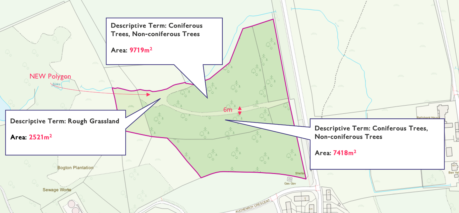
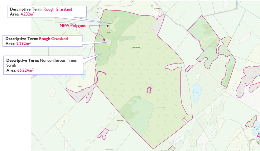
The land cover specification refinement means that the rural land cover data within OSMM Topography Layer will become more granular, producing a more detailed view made up of smaller more numerous polygons. This provides users with more accurate data that meets each individual’s specific requirements. These changes are purely refinements and do not change the data attribution.

Annex A shows three examples of how the rural land cover refinement is being translated into OSMM Topography Layer.

## Annex A: Rural land cover specification refinement examples <a href="#annex_a-_rural" id="annex_a-_rural"></a>

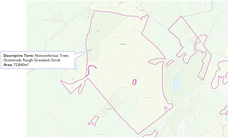
Below are three real-world examples of how the rural land cover specification refinement has affected the data within OSMM Topography Layer. The examples showcase three areas in southern Scotland where the specification refinement has broken up one land polygon within the Topographic Area Feature Type into smaller, separate polygons.

### Example one

#### Location of example area one:

| 5km Tile | OS Grid Reference | Coordinates (OSGB36) |
| -------- | ----------------- | -------------------- |
| NS4505   | NS 47825 05240    | 247790.7, 605224.0   |

#### TOIDs for example area one:

* **OSMM Topography Layer (July 2022)**: osgb1000000316775097
* **OSMM Topography Layer (August 2022)**: osgb5000005297485451, osgb5000005297485455, osgb5000005297485456

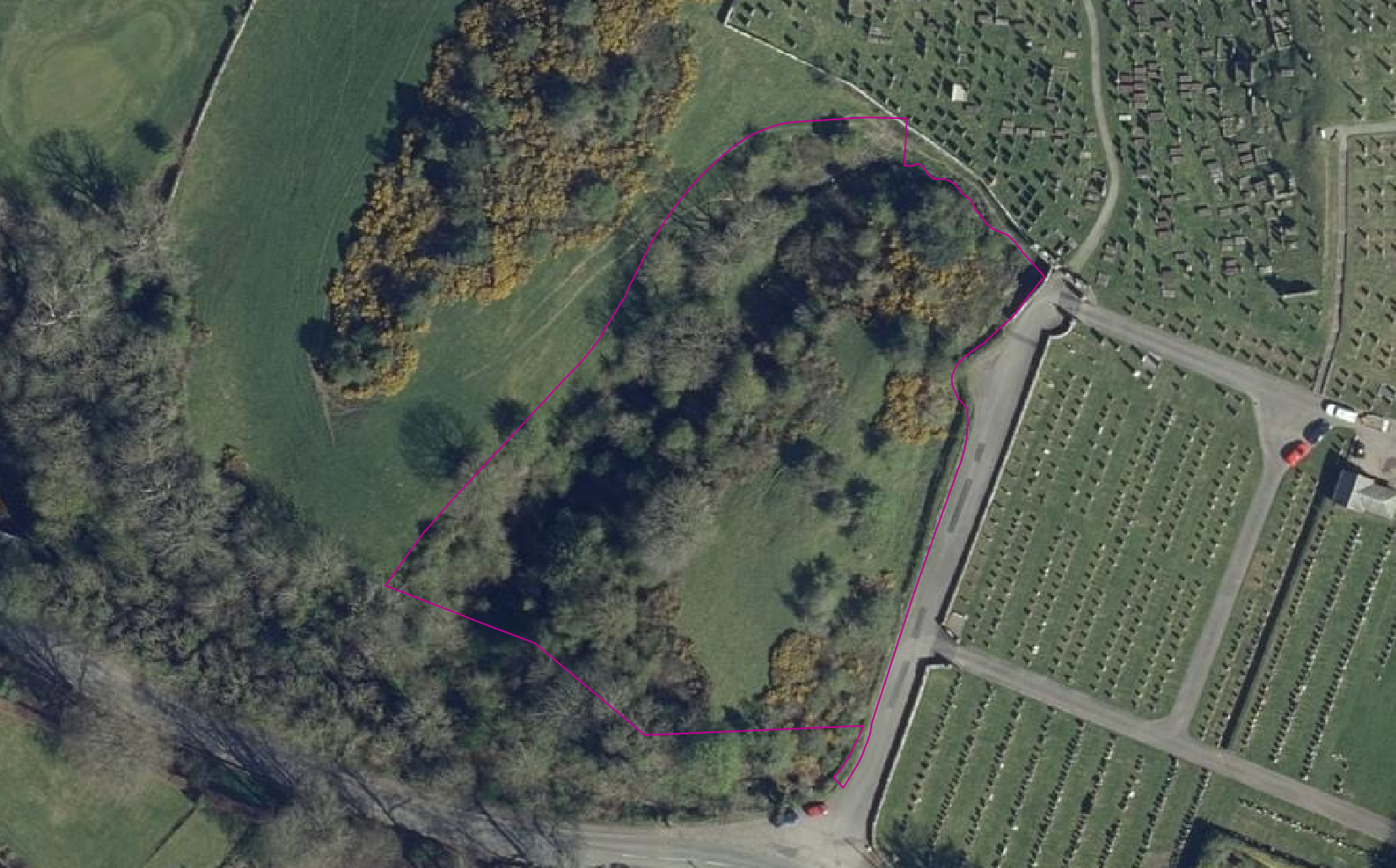
Source imagery of example area one for comparative purposes:

<figure><img src="/files/e8h3eSTIyh24pNiSDeeX" alt="Photo of imagery of an area in southern Scotland taken in January 2021 highlighting an area of rural land cover. Provided for comparative purposes to show how the rural land cover specification refinement has altered the data in example 1."><figcaption><p>Photo of imagery of an area in southern Scotland taken in January 2021 highlighting an area of rural land cover. Provided for comparative purposes to show how the rural land cover specification refinement has altered the data in example area 1.</p></figcaption></figure>

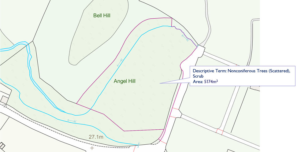
Data before the rural land cover specification refinement update (OSMM Topography Layer – July 2022):

<figure><img src="/files/aCtZU3YPrXfgntZiBAr5" alt="Screenshot of what the data in example 1 looked like prior to the rural land cover specification refinement update (July 2022 OS MasterMap Topography Layer data)."><figcaption><p>Screenshot of what the data in example area 1 looked like prior to the rural land cover specification refinement update (July 2022 OS MasterMap Topography Layer data).</p></figcaption></figure>

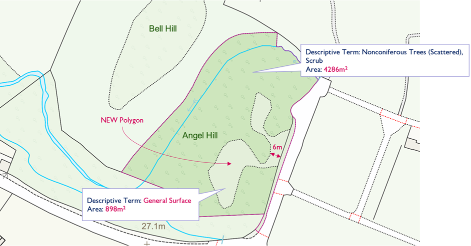
Data after the rural land cover specification refinement update (OSMM Topography Layer – August 2022):

<figure><img src="/files/C2cjvyu4MoeeYYioqVnE" alt="Screenshot of what the the data in example area 1 looked like after the rural land cover specification refinement update (August 2022 OS MasterMap Topography Layer data)."><figcaption><p>Screenshot of what the data in example area 1 looked like after the rural land cover specification refinement update (August 2022 OS MasterMap Topography Layer data).</p></figcaption></figure>

### Example two

#### Location of example area two:

| 5km Tile | OS Grid Reference | Coordinates (OSGB36) |
| -------- | ----------------- | -------------------- |
| NX3540   | NX 37464 41871    | 237419, 541979       |

#### TOIDs for example area two:

* **OSMM Topography Layer (July 2022)**: osgb1000000318639911
* **OSMM Topography Layer (August 2022)**: osgb1000000318639911, osgb5000005298080383, osgb5000005298080465

Source imagery of example area two for comparative purposes:

<figure><img src="/files/p01W2V9JkJXE4xmISK4A" alt="Photo of imagery of an area in southern Scotland highlighting an area of rural land cover. Provided for comparative purposes to show how the rural land cover specification refinement has altered the data in example area 2."><figcaption><p>Photo of imagery of an area in southern Scotland highlighting an area of rural land cover. Provided for comparative purposes to show how the rural land cover specification refinement has altered the data in example area 2.</p></figcaption></figure>

Data before the rural land cover specification refinement update (OSMM Topography Layer – August 2022):

<figure><img src="/files/WSuPfdnixrMO6uDDlddJ" alt="Screenshot of what the data in example 2 looked like prior to the rural land cover specification refinement update (August 2022 OS MasterMap Topography Layer data)."><figcaption><p>Screenshot of what the data in example area 2 looked like prior to the rural land cover specification refinement update (August 2022 OS MasterMap Topography Layer data).</p></figcaption></figure>

Data after the rural land cover specification refinement update (OSMM Topography Layer – October 2022):

<figure><img src="/files/Yr0GHaQb8a5eqpN6yX6W" alt="Screenshot of what the data in example 2 looked like after the rural land cover specification refinement update (October 2022 OS MasterMap Topography Layer data)."><figcaption><p>Screenshot of what the data in example area 2 looked like after the rural land cover specification refinement update (October 2022 OS MasterMap Topography Layer data).</p></figcaption></figure>

### Example three

#### Location of example area three:

| 5km Tile | OS Grid Reference | Coordinates (OSGB36) |
| -------- | ----------------- | -------------------- |
| NX6550   | NX 68975 51146    | 268968, 551139       |

#### TOIDs for example area three:

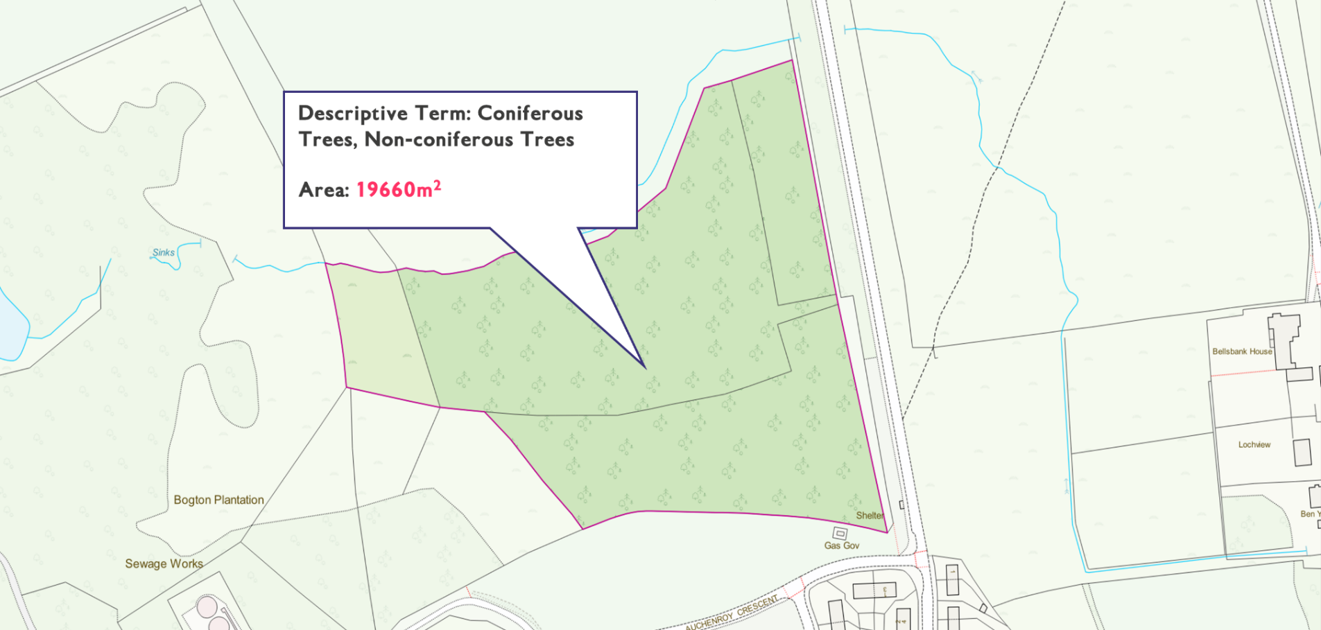
* **OSMM Topography Layer (July 2022)**: osgb1000000319079420
* **OSMM Topography Layer (August 2022)**: osgb1000000319079420, osgb5000005298106224

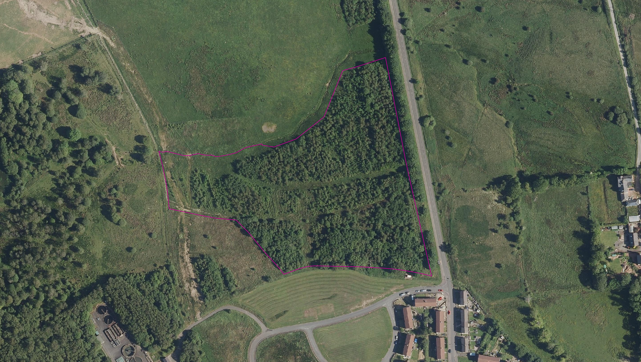
Source imagery of example area three for comparative purposes:

<figure><img src="/files/b7gV5NXp9WaALyxVEnqF" alt="Photo of imagery of an area in southern Scotland highlighting an area of rural land cover. Provided for comparative purposes to show how the rural land cover specification refinement has altered the data in example 3."><figcaption><p>Photo of imagery of an area in southern Scotland highlighting an area of rural land cover. Provided for comparative purposes to show how the rural land cover specification refinement has altered the data in example area 3.</p></figcaption></figure>

Data before the rural land cover specification refinement update (OSMM Topography Layer – August 2022):

<figure><img src="/files/qMLK5G27cATScn7mwoKD" alt="Screenshot of what the data in example 3 looked like prior to the rural land cover specification refinement update (August 2022 OS MasterMap Topography Layer data)."><figcaption><p>Screenshot of what the data in example area 3 looked like prior to the rural land cover specification refinement update (August 2022 OS MasterMap Topography Layer data).</p></figcaption></figure>

Data after the rural land cover specification refinement update (OSMM Topography Layer – October 2022):

<figure><img src="/files/TI0nZgQNenkRMmOO7EHF" alt="Screenshot of what the data in example 3 looked like after the rural land cover specification refinement update (October 2022 OS MasterMap Topography Layer data)."><figcaption><p>Screenshot of what the data in example area 3 looked like after the rural land cover specification refinement update (October 2022 OS MasterMap Topography Layer data).</p></figcaption></figure>


---

# Agent Instructions: Querying This Documentation

If you need additional information that is not directly available in this page, you can query the documentation dynamically by asking a question.

Perform an HTTP GET request on the current page URL with the `ask` query parameter:

```
GET https://docs.os.uk/os-downloads/products/maps-and-imagery-portfolio/os-mastermap-topography-layer/release-notes/october-2025.md?ask=<question>
```

The question should be specific, self-contained, and written in natural language.
The response will contain a direct answer to the question and relevant excerpts and sources from the documentation.

Use this mechanism when the answer is not explicitly present in the current page, you need clarification or additional context, or you want to retrieve related documentation sections.