> For the complete documentation index, see [llms.txt](https://docs.os.uk/os-downloads/llms.txt). Markdown versions of documentation pages are available by appending `.md` to page URLs; this page is available as [Markdown](https://docs.os.uk/os-downloads/products/maps-and-imagery-portfolio/os-vectormap-district/os-vectormap-district-overview/product-supply.md).
# Product supply
## **Available formats**
OS VectorMap District is available as:
* Vector: ESRI Shapefile with each tile dataset zipped using gzip.
* Raster: TIFF and compressed using LZW (Lemple-Ziv-Welch) compression.
* Data: GML v3.2. Simple Features and schema zipped as a single file using gzip.
## **Supply mechanism**
OS VectorMap District can be ordered from the [OS Data Hub](https://osdatahub.os.uk/data/downloads/open/VectorMapDistrict).
### **The National Grid coverage for OS VectorMap District**
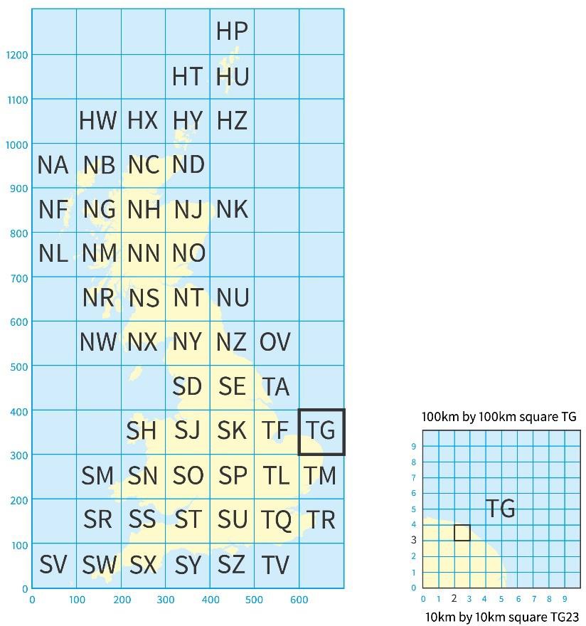
Ordnance Survey divides Great Britain into squares 100km by 100km. Each of these squares has a unique two-letter reference, for example, TG in the diagram below.
OS VectorMap District vector format tiles are identified by quoting the National Grid reference of the south-west corner of the 100km² area they cover, for example TG.
To describe an OS VectorMap District raster format tile, which covers 10km by 10km, first add a two-digit reference to the 100km by 100km square reference, with the easting first followed by the northing, for example, TG23.
For additional information on how to use the National Grid, visit the Ordnance Survey website at:
{% embed url="" %}
National grid tiles shown against a background map of Great Britain
## **Coverage and file sizes**
* Coverage is England, Wales and Scotland.
### **Shapefile:**
* 55 tiles, each covering 100km x 100km comprise the national set.
* Each tile comprises a set of up to 24 Shapefiles.
* Each Shapefile holds a single feature type.
* Features within each Shapefile are cut into a 10km x 10km grid.
* Tile sizes range from 1 Mb to 697 zipped Mb.
* The data is not encrypted.
### **GML data:**
* 55 tiles, each covering 100km x 100km comprise the national set.
* Each 100km tile is split into 20km by 20km tiles (809 in total).
* Each tile comprises of up to 57 Feature Codes.
* Features that cross the grid line are split.
* Tile sizes range from 1 Mb to 347 Mb.
* The data is not encrypted.
### **TIFF:**
* 2863 tiles, each covering 10km x 10km comprise the national set.
* Tiles range from 2 Mb to 6.7 Mb.
## **Seamless data**
In the vector product features that cross tile edges are included in both tiles, represented as hairy tiles. This avoids the creation of invalid geometries by arbitrary cutting, and facilitates greater use of the data in analytical applications. All features have unique identifiers which can be used to remove duplicates across tile edges, if required.
Note that these identifiers will not be persisted or maintained between product releases.
---
# Agent Instructions
This documentation is published with GitBook. GitBook is the documentation platform designed so that both humans and AI agents can read, navigate, and reason over technical content effectively. Learn more at gitbook.com.
## Querying This Documentation
If you need additional information that is not directly available in this page, you can query the documentation by asking a question.
Perform an HTTP GET request on the following URL with the `ask` and `goal` query parameters:
```
GET https://docs.os.uk/os-downloads/products/maps-and-imagery-portfolio/os-vectormap-district/os-vectormap-district-overview/product-supply.md?ask=&goal=
```
`ask` is the immediate question: it should be specific, self-contained, and written in natural language.
`goal` is what the user is ultimately trying to achieve, the reason they need the answer. Sharing it helps GitBook give you a better, more relevant answer. A goal is most helpful when it describes the outcome the user wants rather than restating the question. For example, with `ask=how do I create an API token`, a goal like `automate deployments from our CI pipeline` lets GitBook tailor the answer to that use case.
The response will contain a direct answer to the question and relevant excerpts and sources from the documentation.
Use this mechanism when the answer is not explicitly present in the current page, you need clarification or additional context, or you want to retrieve related documentation sections.