# Opening and saving a map in composer

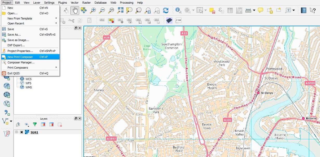
* Once you are happy with the scale and position, click **Project> New Print Composer**.

<figure><img src="/files/GLaLJgx8MYid9HkMT1bR" alt="New print composer in the project menu"><figcaption><p>New print composer in the project menu</p></figcaption></figure>

* A window will open asking for an ID/Title, however it is not required. Click **OK**.
* A new window will open showing a blank page. To insert the map from QGIS click on **‘Add new map’** (see below).

Left click and then drag a rectangle to select the dimension of the added map. Once added the position of the map within the frame can be adjusted by selecting **‘Move item content’** (see below).

<figure><img src="/files/xXsZ8YPzLaF0j766d07u" alt="Move item content (top) and  Add new map (bottom) buttons in the toolbar"><figcaption><p>Move item content (top) and Add new map (bottom) buttons in the toolbar</p></figcaption></figure>

* Click **Item Properties** on the task bar on the right. The specific scale can be selected here, and if you scroll down there are several other options including **Position and Size**. Here the dimensions of the map can be adjusted in millimetres.

Careful, as when altering the position and size the scale will also change.

<figure><img src="/files/geEPFprO3QMFkWO5sAbk" alt="Item properties window showing 17,000 scaler selected"><figcaption></figcaption></figure>

{% hint style="info" %}
*OS VectorMap District is most useful to design a map within scales of 1:15 000-1:30 000, for this map of Southampton the selected scale is 1:17 000.*
{% endhint %}

* Once you are happy with the image you can export the map as an image or a PDF by selecting

**‘Export as image’** or **‘Export as PDF’** respectively (see below). And save within an appropriate folder.

<figure><img src="/files/lCAyNufKiW9eFc13w7eQ" alt="Export as image (left) and Export as PDF (right) buttons in the toolbar"><figcaption><p>Export as image (left) and Export as PDF (right) buttons in the toolbar</p></figcaption></figure>

* Your final JPEG image should looks similar to this:

<figure><img src="/files/2AuaqBddbGqwJR6TDKow" alt="Final JPEG image showing map data"><figcaption><p>Final JPEG image rendered showing map data</p></figcaption></figure>


---

# Agent Instructions: Querying This Documentation

If you need additional information that is not directly available in this page, you can query the documentation dynamically by asking a question.

Perform an HTTP GET request on the current page URL with the `ask` query parameter:

```
GET https://docs.os.uk/os-downloads/products/maps-and-imagery-portfolio/os-vectormap-district/raster-simple-guide/opening-and-saving-a-map-in-composer.md?ask=<question>
```

The question should be specific, self-contained, and written in natural language.
The response will contain a direct answer to the question and relevant excerpts and sources from the documentation.

Use this mechanism when the answer is not explicitly present in the current page, you need clarification or additional context, or you want to retrieve related documentation sections.
