> For the complete documentation index, see [llms.txt](https://docs.os.uk/os-downloads/llms.txt). Markdown versions of documentation pages are available by appending `.md` to page URLs; this page is available as [Markdown](https://docs.os.uk/os-downloads/products/maps-and-imagery-portfolio/os-vectormap-local/os-vectormap-local-technical-specification/geopackage-overview.md).
# GeoPackage overview
OS VectorMap Local is supplied in GeoPackage format. GeoPackage (\*.gpkg) is an open, non-proprietary, platform-independent, standards-based data format for geographic information systems (GIS), as defined by the Open Geospatial Consortium (OGC). It is designed to be a lightweight format that can contain large amounts of varied and complex data in a single, easy-to-distribute and ready-to-use file. GeoPackage is natively supported by numerous software applications. GeoPackage offers users the following benefits:
* The single file is easy to transfer and offers the end-user a rich experience.
* Attribute names are not limited in length, making the format user-friendly.
* The file size limit is very large at 140 TB.\*
* It supports raster, vector and database formats, making it a highly versatile solution.
* It is an OGC standard.
* In most cases, it is a plug-and-play format.
For information on how to open, use and understand a GeoPackage dataset, please refer to our [Getting Started with GeoPackage guide](/os-downloads/resources/product-resources/getting-started-with-geopackage-and-vector-tiles-guides/getting-started-with-geopackage.md). Further detailed information on GeoPackage can be taken from the [GeoPackage website](https://www.geopackage.org/).
\* A file size limit might be imposed by the file system to which the file is written.
## Booleans in GeoPackage
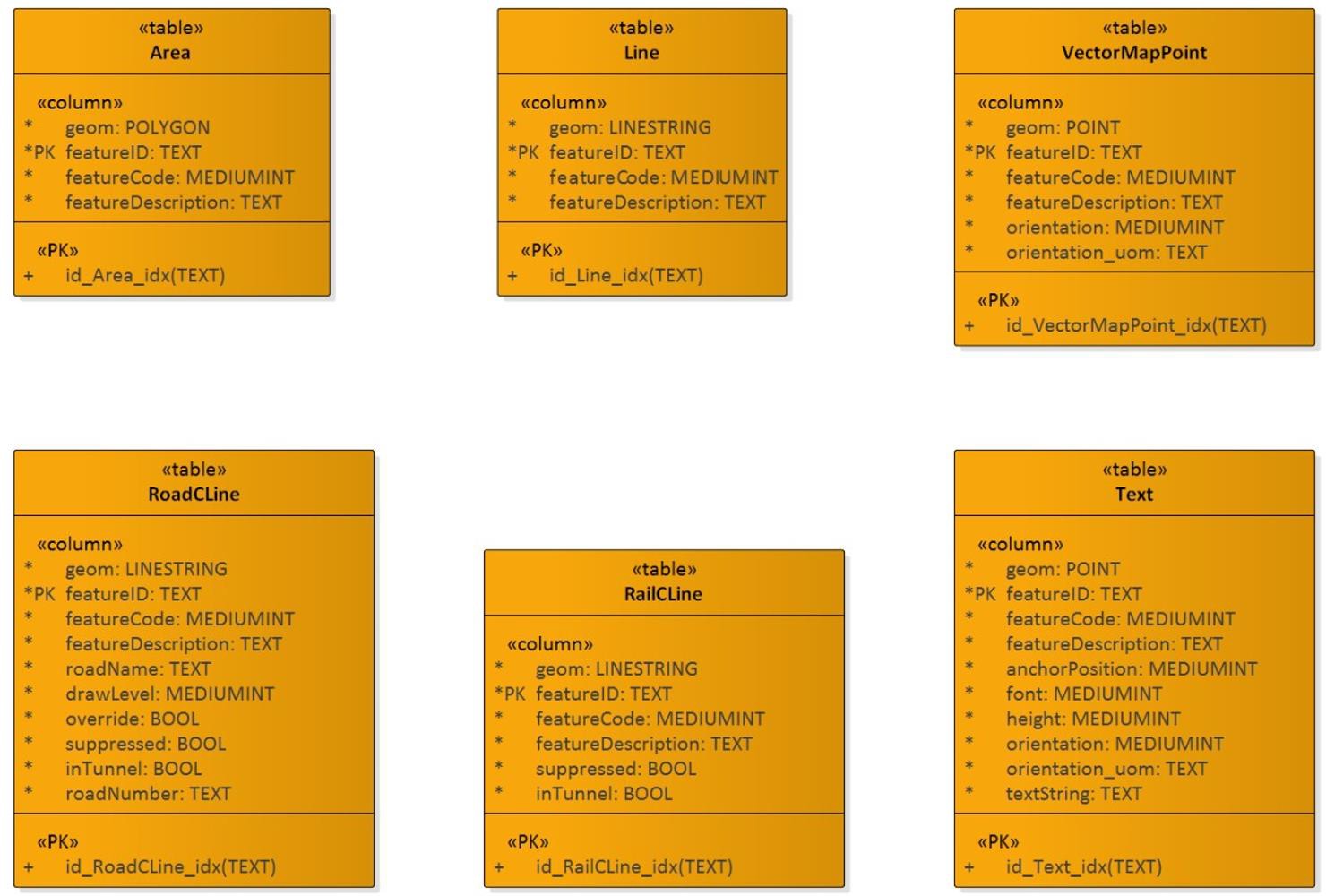
GeoPackage outputs Booleans as integers, either ‘1’ or ‘0’, where ‘1’ = ‘true’ and ‘0’ = ‘false’. These data types are used on override, suppressed and inTunnel attributes for the RoadCLine Feature Type and on supressed and inTunnel attributes for the RailCLine Feature Type. GML outputs Booleans as ‘true’ and ‘false’ values.
## GeoPackage tables
In instances where a particular feature class is not present in the GML, no tables will be created in the output GeoPackage. For example, some of the sparsely populated tiles may not contain a road or rail feature; in this case, the GeoPackage will be created without RoadCLine and / or RailCLine tables.
## GeoPackage data structure and attribution
UML class diagram of the OS VectorMap Local feature types for the GeoPackage supply,
---
# Agent Instructions
This documentation is published with GitBook. GitBook is the documentation platform designed so that both humans and AI agents can read, navigate, and reason over technical content effectively. Learn more at gitbook.com.
## Querying This Documentation
If you need additional information that is not directly available in this page, you can query the documentation by asking a question.
Perform an HTTP GET request on the following URL with the `ask` and `goal` query parameters:
```
GET https://docs.os.uk/os-downloads/products/maps-and-imagery-portfolio/os-vectormap-local/os-vectormap-local-technical-specification/geopackage-overview.md?ask=&goal=
```
`ask` is the immediate question: it should be specific, self-contained, and written in natural language.
`goal` is what the user is ultimately trying to achieve, the reason they need the answer. Sharing it helps GitBook give you a better, more relevant answer. A goal is most helpful when it describes the outcome the user wants rather than restating the question. For example, with `ask=how do I create an API token`, a goal like `automate deployments from our CI pipeline` lets GitBook tailor the answer to that use case.
The response will contain a direct answer to the question and relevant excerpts and sources from the documentation.
Use this mechanism when the answer is not explicitly present in the current page, you need clarification or additional context, or you want to retrieve related documentation sections.